


In the past 150 years if creeks were taken into account at all it was just as scenery for a tightly manicured park. Wetlands were mined, drained or filled, “reclaimed”, as they liked to put it, and creeks were shunted off if they were inconveniently placed relative to someone’s short-term desire, (usually for profit). The cumulative effect has been disastrous.
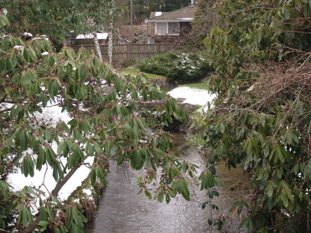
Urban development as a whole is bad for streams- McAleer Creek, for instance, originates in Lake Ballinger, but its upper reach has been almost denuded of native vegetation (park, golf course) and is covered completely for a few hundred feet by I-5. King County’s assessment says “The middle subbasin consists primarily of low-density residential land use with deep ravines and eroded soils. The lower basin flattens and fans into a floodplain across what is now the Lake Forest Park Mall and Bothell Way.”
It can surprise no one that, “Transport of suspended sediments has been significant in McAleer Creek,” because the native forest soaked up over 99% of the rain, but replacing it with impervious surfaces- roads, driveways, roofs- dramatically increases the amount and speed of runoff. Remember, under the thin soil this whole region is just sand, gravel, and clay. Run a lot of water on the unprotected dirt and the dirt ends up in the creek. “The incising of stream banks and soil erosion was one of the major reasons the 1993 McAleer Creek Project Plan was undertaken. The plan, produced for King County, Mountlake Terrace, and Lake Forest Park, recommended solutions to flooding problems in the drainage basin.”
Find out what's happening in Shoreline-Lake Forest Parkwith free, real-time updates from Patch.
“Daylighting” is a term you’ve read here before, but you may not be familiar with it. It means restoring a stream which has been diverted into a culvert- a big pipe- to the surface in as close to its natural bed and condition as possible. Stream water is- no surprise- the essential element of riparian (creeks and rivers) ecology. Take it away and the whole assemblage is impoverished.
“Since 1997 volunteers with the Salmon Watcher have been recording salmon observations in McAleer Creek. Volunteers have consistently seen chinook, coho, and sockeye in the creek. No kokanee salmon or cutthroat trout have been seen.” according to King County. Other observers claim Kokanee and Cutthroat are there as well. This is a big deal not only because we like salmon, but because they’re protected.
Find out what's happening in Shoreline-Lake Forest Parkwith free, real-time updates from Patch.
The National Oceanographic and Atmospheric Administration announced that Puget Sound Salmon is “Listed as a threatened species on March 24, 1999; threatened status reaffirmed on June 28, 2005. The ESU includes all naturally spawned populations of Chinook salmon from rivers and streams flowing into Puget Sound…” As the Lake Forest Park Stewardship Foundation stated in 1999, the “…listing of several Puget Sound salmon species as threatened has brought all spawning grounds into the spotlight. We are learning that the protection of these areas must be a responsibility felt by everyone, whether we live near a stream or not.”
The law requires that we do whatever we can to preserve and restore salmon habitat, yet in the Greater Lake Ballinger/McAleer Creek Watershed Study, prepared by Otak, Inc. for the cities of Edmonds, Lake Forest Park, Mountlake Terrace, and Shoreline, it defines the problem as flooding and says “Conclusion: Due to the severity and magnitude of these alterations throughout the Watershed Area, it is not likely that the natural water balance will be able to be effectively re-established without eliminating the impervious surfaces and replanting to reestablish native vegetation and soils. This approach would be very expensive and would require many years to mimic the forested conditions in the Watershed Area.”
Flooding is clearly not the problem at all, but merely the most obvious symptom. The problem is “the severity and magnitude of these alterations” because they led directly to the flooding and habitat loss, and the solution, however expensive and long-term is to start re-establishing that “natural water balance” and yet LFP is trying to put McAleer and Lyons creeks into culverts.
Perhaps the same cities which cooperated to do this study could set up a collaborative agency to oversee the watershed restoration. It makes sense that LFP would pay into the real solution to their flooding and that the upstream cities should pay to make up for decades of floods LFP has had to deal with. Shoreline and the others should expand the “green streets” program starting at stream edges and moving out from there, reducing the runoff problem first where it will do the most immediate good. This needn’t cost more, as it can be done on the normal schedule of repaving. Granted, the faster we do it the faster we see improvements. Cities and their residents should realize that the term “flood plain” is literal, and if buildings must be moved, so be it. Homeowners should be required to do best-practices in their landscaping to reduce runoff and its potential toxicity. Required? Yes. One person’s poor choice affects all.
If I counted right the Otak report estimated $94 million would be needed for culverts and other impositions. Pour it into righting the old wrongs from the headwaters down and we’ll never have to deal with it again!